Implemented by
| Supported by
Implemented by Capital Consulting Corporation & Kansas State University – Salina, Supported by NIST & PSCR
About the First Responder Uncrewed Aircraft System (UAS) 3D Mapping Challenge (UAS 5.0)
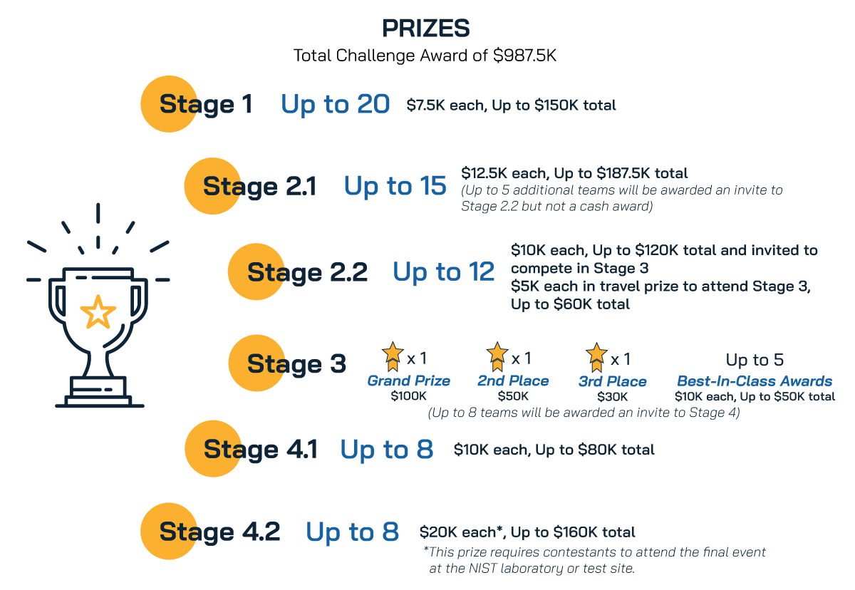
Compete for $987.5K in total prizes plus a chance to demo your prototype at a live competition and participate in an accelerator program to further your research or market readiness
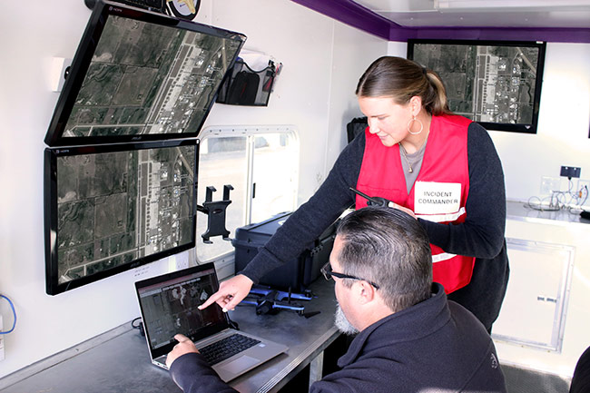
As a firefighter, the need to investigate accidents and prepare for rescues requires collecting visual and location data about a structurally compromised facility and people in the facility without entering it. In this situation, having real-time data (more than just a live video feed) is imperative to gain situational awareness and to plan for the deployment of critical resources to achieve the mission objectives. Incident Commanders operating in this scenario need to prioritize critical resources and make decisions for a timely response. In addition to precisely locating people in the facility, a real-time 3D map could help identify obstacles and other hazardous conditions around the people that would be important for the planning of ingress and egress routes. These conditions could include smoke, a partially collapsed structure, limited or no lighting, and a GPS-denied infrastructure.
The outcomes of an ideal UAS solution will be an affordable solution that provides accurate positioning and high-quality 3D digital mapping real-time, supports public safety budgets, and complies with national security requirements.
America’s First Responders need your support!
Focused on supporting the needs of the public safety community and its stakeholders.
Could your UAS win a competition by providing an affordable UAS solution with accurate positioning and high-quality 3D digital mapping for first responders operating in indoor, constrained environment?
Key Details
The Mission
To provide an affordable UAS solution with accurate positioning and high-quality 3D digital mapping for first responders to accomplish their missions in indoor, constrained environments.
Imagine a scenario where First Responders need to obtain real–time situational awareness in an indoor environments that have been compromised by severe damage due to fire, flood, structural collapse, and other potentially dangerous situations.
The Breakthrough
Accept this Challenge to develop an indoor UAS platform that provide an affordable UAS solution with accurate positioning and high-quality 3D digital mapping for first responders to accomplish their missions in indoor, constrained environments.
The Plan
Sign up for our newsletter to receive updates about the First Responder Uncrewed Aircraft System (UAS) 3D Mapping Challenge (UAS 5.0)

Next Steps
Contestant Portal
Phase 2.2 submissions are now open.
- All entries for future phases, including Phase 2 walk-ons must be submitted through the Contestant Portal
- Click “JOIN CHALLENGE” when you are redirected to the Contestant Portal hosted by “BestinCrowd.”
- If you are a first-time user, sign up using your social media login or create a new account on the Contestant Portal hosted by “BestinCrowd.”
- Join the challenge as an individual or a team. If you haven’t recruited all your team members, don’t worry – additional team members can be invited later.
- If you are competing as a team, only the Official Representative (i.e., team lead) may submit your team’s concept paper and required documents.
- You may replace your submission as often as you wish until the deadline.
If you have any questions, please contact us.
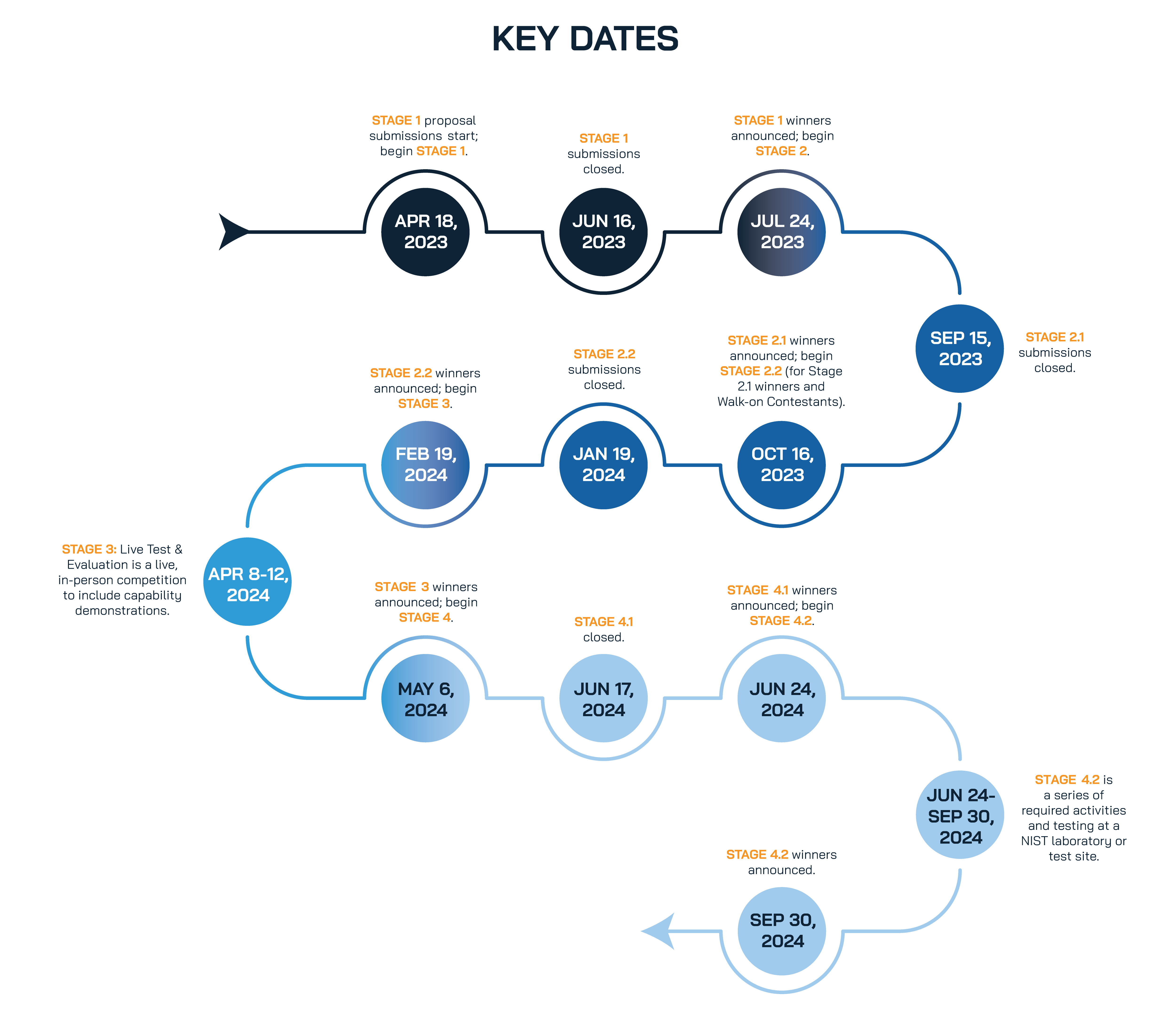
Key Dates
Prizes
Implemented by
| Supported by
Implemented by Capital Consulting Corporation & Kansas State University – Salina, Supported by NIST & PSCR


